Certain tools are indispensable to the historian. I staged the image below by way of illustration. We could play one of those memory games where you look at the image for a little minute and then I whisk it away and hide it under a dish towel and you make a list of everything you remember, but we all know that could be a depressing experience, so I have another game. Make a list of all the tools you recognize** and then tell which one is 50 years old.
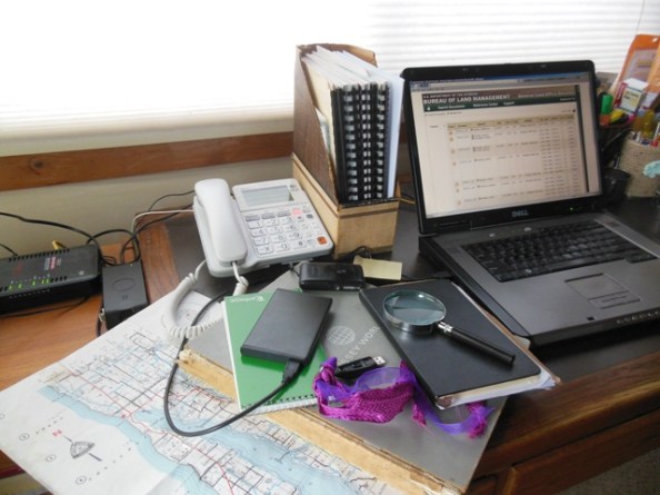
If you guessed the Odyssey World Atlas you are right. In fact, if you guessed “the big gray book with the ratty spine” you’re right.

I love that Atlas, and I use it all the time, even though it is badly out of date and falling apart. I use online maps and atlases all the time, too, but the old gray book is always at hand. When a URL changes, or the internet is down, or the power is out I can still look something up by the light of an oil lamp. You’d be surprised how often that happens Around Here.
Of course if the internet or power is gone and what I want to look up has anything to do with the current boundaries of a number of African nations, or of the European or Asian nations which were once part of the Union of Soviet Socialist Republics, or the very existence of the European Union, I am out of luck–unless I can remember where I put the newer Atlas that I picked up at a library sale for just these little emergencies.
My good old Atlas has some excellent qualities. It tells me as much as I want to know about projections, has maps of physical features and political boundaries, and shows the designs of national flags. Best of all, it has nice big maps of individual Canadian provinces and American states complete with county boundaries and rivers and mountain ranges. Wisconsin and Michigan are on facing pages, which is very convenient for me.


It also betrays some deeply flawed notions of race and religion and is clearly focused on the northern hemisphere, particularly Canada and the U.S. It is not a perfect Atlas.
Nevertheless, it has served me well, and I am used to its quirks, the way a person becomes used to the peculiarities of a beloved elderly relative. These days I often use that magnifying glass to peer at the tiny print where rivers converge. I put sticky notes all over the pages when I’m tracing family members or beloved Civil War veterans. I can’t imagine taking the Atlas to the recycling center.
Happy 50th Anniversary, old friend. Here’s to many more.
**For those of you who want to know how many right answers you got on the tools list, here’s the whole thing: modem, laptop charger, telephone, Antrim County map with section lines (I love that map), old gray Odyssey World Atlas, green journalist’s notebook for recording interview notes, magnifying glass, black Moleskine notebook for recording important stuff, USB drive with fancy ribbon attached so I can always find it in the bottom of my purse, black external hard drive (surgically removed from my old laptop and put in a handy new case), pad of sticky notes, black spring clip for holding important stuff together, little camera for making pictures of important stuff, old-fashioned cardboard vertical file for holding old-fashioned printed research materials, current laptop. You know what’s missing? A pen and a pencil. I lose those all the time.

Martha
April 3, 2016
I can appreciate your feelings. I was brought up to not be sentimental (failed lesson), but there are things…Mostly stuffed animals from my childhood. I have a sweet white fabric dog in the style of a fox terrier that I can’t and won’t part with. We went through tough times together. He’s 53 years old. I suppose we will both be cremated. Will they let you be cremated with stuffed toys? I suppose no one but the guy who turns up the heat really can answer that.
Books, I think have their own life. I can let them go on to a new life with a new reader. In my mind they need to continue their journey without us. Having said that, not all of my books get set free. I will hold on to a few tough ones, but I know someday they will find new life with someone else. That comforts me.
May you and your Atlas never part until it is time.
Gerry
April 3, 2016
I am pretty sure that a cremation facility will be happy to accommodate a fox terrier stuffed toy. We have discussed my desire to become a white pine–although NOT JUST YET!! Perhaps my Atlas could accompany me to the great forest.
I like to pass books on to other readers. Unfortunately I have a hard time letting go of them. Must work on that.
WOL
April 3, 2016
Well, the best I can come up with is a massive orange glass ash tray I got in the 1970’s which I used to use for an ashtray. However it is just the right size, shape and weight (about a ton) for a ball of yarn, which is what I’ve used it for since 1987 when I quit smoking. It’s sitting on my desk as I type with a ball of white lavender and pink variegated yarn that is currently being knitted into a baby afghan. Yes, I knit while at the computer reading blogs. You know what they say about idle hands being the devil’s workshop. . .
Gerry
April 4, 2016
Oh my – I had a heavy amber and cream glass ash tray of a similar vintage. It, too, was retired at least 30 years ago when I had the good sense to quit smoking for the last time. I have no idea where it is now. I am impressed with your clever recycling and with your ability to read blogs and knit at the same time.
Martha J
April 4, 2016
Loved the story of your atlas. I get really frustrated trying to look at maps online and forget even trying to look at one on an e reader. I try to get all my history books in actual book form for that reason – to pour over the maps. In other news, have you seen those very cool ‘lending libraries’ around? I saw one near me that was at the end of someone’s drive and it had a little shingle roof and glass front so you could see the books. I looked them up once and apparently it is a big thing all across the country with people building these and loaning out books for free. Maybe I will try to get a picture of it and send it to you. Of course I could be way behind the times and you are thinking “well, of course I know all about those”.
Gerry
April 4, 2016
I love to study the maps in history books, too. I’ve been known to take a picture of a particularly interesting map and load it onto my big monitor so I can consult it while I read about the events that took place there. The best ones of all, of course, are the nice fold-out ones that used to come with particularly good books.
I have indeed seen the little free lending libraries, and I love them. I would like to see a picture of the one in your neighborhood. They’re quite popular Around Here, and I’ve thought of putting one up next to my mailbox. I could certainly benefit from loading it up with books every now and then. There is a very nice one on the “town” side of the pedestrian bridge to the Elk Rapids Library. It was designed to resemble the library, which is even more appealing than its tiny pal.
P.j. grath
April 4, 2016
We are clearly on the same wave length again, Gerry. Just Saturday, at my bookstore, I put a relatively recent (used) road atlas on one of the front tables (a brand-new 2016 one was on the other) and then added an old atlas from — was it 1905? I’m not there right now but will check. Yes, often handy, especially when the power goes out. But always interesting, too.
Gerry
April 4, 2016
Ooh, ooh – a 1905 atlas of where??? I love those old atlases, especially the ones about Places of Interest in my wandering history journeys.
Craig Smith
April 4, 2016
Fun picture puzzle! Like “Highlights Magazine” for Boomers. I’m never giving up my Cold War-era Britannica Atlas.
Gerry
April 4, 2016
But does Britannica help you find Harney County?
tootlepedal
April 4, 2016
I am a mapaholic so I can empathise with your atlas love.
Gerry
April 4, 2016
You have come to the right place. One day I will have to discuss my father’s map obsession. Another day we can go to the antique map establishment.
tootlepedal
April 5, 2016
I have the complete Ordnance Survey 1:50000 set of maps of the UK on my computer so I can go anywhere…..as long as I don’t stray from my computer seat.
Gerry
April 5, 2016
I am impressed. I have a lot of paper maps so I can go anywhere . . . as long as I carry a very big magnifying glass and stop at the side of the road frequently. We will have to revisit maps. They are lovely things.
shoreacres
April 5, 2016
I love maps. Maps are how I travel — along with the sun, moon, and stars. I used a GPS once, to find an old cemetery in the midst of Kansas. It was dead-on in its directions, except it failed to note the washed out bridge. Lucky that a local in a pickup happened by, to offer a useful alternative route.
Speaking of good books that come with maps, I happen to have one. And it’s new! There’s a small press here in Texas that makes a business of bringing back into print old books on Texas history. I’ve purchased three. The one with the map is Ferdinand Roemer’s account of his travels throuigh the state, 1845-1847. There’s even a photo available for you to admire. I suspect you’ll hear more about him on my blog.
Gerry
April 5, 2016
Ohboyohboy LOOK AT THAT MAP! Of course you bought the book. How could you resist?